Geology and Formations
Wasaga Beach Provincial Park is made up of both active and historic shorelines. A swim or walk at the lake shore has you experiencing an active shoreline, while a walk in the 800-hectare Dunes Area of the park has you exploring parabolic dunes measuring 40 metres in height. The beach and dunes are constantlychanging through a process called saltation which occurs when loose materials, such as sand, are removed from a bed and carried by fluids such as wind or water, before being transported back to the surface. Wasaga Beach is a relict beach meaning that the sand which currently resides on the beach is the only sand the beach will ever have. The sand does not replenish itself unlike ocean beaches. For these reasons it is important to preserve our beaches and dunes. Visitors can help with this by using designated pathways to avoid erosion and destruction of dunes. Continue reading below for more information on the historic formation of the beach and dunes systems.

Wasaga Beach shoreline
Upon final deglaciation of the Southern Georgian Bay region, about 10,000 – 12,000 years ago, the Wasaga Beach area was entirely submerged to a depth of over 70 m in glacial Lake Algonquin, a lake which covered much of Lakes Huron, Michigan, and Superior. Following the rapid drainage and emptying of the glacial lake through outlets in the North Bay area, about 10,000 years ago, Wasaga Beach, and most of the Georgian Bay basin, was left high and dry while a small lake, Hough Lake, occupied the centre of the basin. During this time, vegetation encroached over the land surface.
A period of high waters followed and is known as the Nipissing transgression. The transgression began 8,000 years ago and rose to its highest level about 4,700 years ago. This lake stage created a large embayment towards the southeast of the park area. Beneath its shallow waters, waves eroded and reworked the existing deposits in the offshore and adjacent highlands to form a barrier island across the embayment. The barrier island may have been joined eventually to the mainland to the west by the development of a spit. A large shallow lagoon lay behind the barrier system.
During the lowering of the Nipissing Lake stage to present levels, sand on the beach and barrier system was mobilized by winds, forming low transverse and irregular dunes on top of the bar, and high parabolic dunes on the distal flank of the bar. The lowering lake levels is marked by a series of over 40 raised beaches on the lakeward side of the barrier bar.
Today Wasaga Beach consists of: a modern shore system marked by a wide, sand beach, spit, and offshore ridges; a zone of low foredunes; high, transverse, parabolic dunes; and floodplains and wetlands associated with a drained lagoon. The park is noted for preserving one of the largest, uninterrupted systems of parabolic dunes in the province. For this reason, motorized vehicles, fires, and hunting are not allowed in the dunes area.
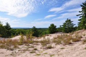
Parabolic dune system